الوضع الليلي


 3:7:7
3:7:7  2026-09-07
  792
792
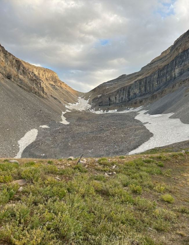
A mountain of loose rock in Utah hides enough ice to fill 600 Olympic swimming pools, revealing that some of the state’s largest frozen water reserves are almost invisible from the surface.
Unlike conventional glaciers, which expose broad expanses of ice, rock glaciers resemble slowly shifting fields of broken stone. Their rocky coverings can conceal thick bodies of ice while insulating them from direct sunlight and warm air.
These formations are widespread in Utah’s Wasatch and Uinta ranges and also appear on the Colorado Plateau in the La Sal Mountains near Moab. One of the largest lies beneath Mount Timpanogos, the prominent peak overlooking communities near Salt Lake City and Provo.
Hidden Ice Beneath Mount Timpanogos
Two University of Utah studies have now revealed how Timpanogos Rock Glacier formed and how much frozen water it contains. The researchers estimate that ice makes up 83% of the formation, while loose rock accounts for the remaining 17%.
That buried ice holds approximately 1.5 million cubic meters (53 million cubic feet) of water. The volume would fill 600 Olympic swimming pools and is comparable to that of the largest pyramid at Giza in Egypt, according to Bronson Cvijanovich, a former graduate student in the Department of Geology & Geophysics.
“Timpanogos Rock Glacier is surprisingly ice-rich. It is 83% ice and 17% loose rock,” said Cvijanovich, lead author of one study conducted under geophysics professor Michael Thorne and glaciology professor Leif Anderson.
“There’s a lot of ice that’s hidden in Utah’s mountains,” Anderson said. “When we are high in the mountains and walking across loose rocks or rubble, you don’t realize there could be 120 feet of ice buried beneath your feet.”
Mapping Ice With Gravity
Because the ice is hidden beneath rubble, researchers cannot measure it using ordinary surface observations. Satellite images can outline a rock glacier, but they reveal little about the depth, shape, or volume of the frozen material inside.
Cvijanovich led six expeditions to Timpanogos Rock Glacier in the fall of 2024, carrying sensitive instruments to the formation above Emerald Lake. Using a state-of-the-art gravimeter, he collected readings at 232 points arranged in a grid, with each location separated by 25 meters (~80 feet).
The method takes advantage of a basic physical contrast: ice is much less dense than rock. Areas containing thicker ice exert a slightly weaker gravitational pull, allowing scientists to reconstruct the buried ice body without drilling into it.
“There is a large contrast in mass density between the rock that makes up Mount Timpanogos and the much lower density ice that is in rock glacier adjacent to it,” Thorne said. “When we measure the gravitational acceleration over the rock glacier, we see a larger decrease in that gravitational acceleration as we make measurements over areas with thicker ice.”
A Three-Dimensional View Underground
The measurements required careful correction because gravity varies with elevation, latitude, surrounding terrain, and even the positions of the sun and moon. After accounting for those influences, the team used Bayesian statistics to calculate the most likely three-dimensional shape of the hidden ice.
“We spent months of computation time doing the imaging with our new techniques,” Thorne said.
The result functions somewhat like a CT scan of a human body. Instead of using radiation to reveal bones and tissues, the approach uses minute changes in gravity to map ice buried beneath a thick layer of rocky debris.
The technique could give scientists a practical way to estimate the contents of other rock glaciers, many of which are too remote or unstable for extensive drilling. It also exposes a part of the mountain water system that traditional glacier surveys can easily overlook.
How Utah’s Rock Glaciers Formed
Rock glaciers often develop beneath steep-walled valleys or cirques where erosion repeatedly sends stones tumbling onto persistent snow. As the debris accumulates, it buries the snow and helps protect the resulting ice from the surrounding environment.
“In the Wasatch, the mountains themselves are eroding and burying the snow, and that’s why the rock glaciers exist,” Anderson noted.
The researchers developed a mathematical model describing this process. It shows how rockfalls add mass to a rock glacier by covering long lasting snow in its upper reaches, gradually building a mixture dominated by ice beneath a rocky surface.
The second study found that Utah’s rock glaciers are not direct remnants of the Ice Age (which reached its peak 21,000 to 18,000 years ago). Instead, they formed during the thousands of years after the region’s ancient glaciers disappeared, making them younger frozen reservoirs rather than leftover pieces of the original ice sheets.
A Global Reserve of Frozen Water
Satellite surveys have identified 836 rock glaciers in Utah alone. Using the relationship between surface area and ice volume measured at Timpanogos, the researchers created a way to estimate how much ice may be hidden inside other formations.
When applied to the roughly 50,000 known rock glaciers worldwide, the calculation suggests that they collectively store about 48 gigatons of water. One gigaton equals 1 billion metric tons and corresponds to approximately one cubic kilometer (0.24 cubic miles) of water, enough to fill 400,000 Olympic swimming pools. According to the researchers, Utah’s rock glaciers may contain about 1 gigaton of water, equivalent to 815,000 acre-feet.
Reality Of Islam |
|

Keeping sil
Two experim
Changing a
Plants are
 9:3:43
2018-11-05
9:3:43
2018-11-05
10 benefits of Marriage in Islam
7:5:22
2019-04-08
benefits of reciting surat yunus, hud &
9:45:7
2018-12-24
advantages & disadvantages of divorce
11:35:12
2018-06-10
6:0:51
2018-10-16
11:34:48
2022-06-29
7:45:39
2018-06-21
10:35:40
2022-05-26
12:47:1
2022-12-20
10:47:11
2022-11-22
7:34:7
2023-02-28
7:59:14
2018-06-21
5:41:46
2023-03-18
| LATEST |
 HOME
HOME