الوضع الليلي


 5:1:52
  2023-10-24
  1829
1829
An ancient river system that has not seen the light of day for at least 14 million years has been discovered underneath the East Antarctic Ice Sheet, new research reports.
With ice-penetrating radar and satellite data, Durham University glaciologist Stewart Jamieson and colleagues mapped the topographic features of the landscape hidden beneath the East Antarctic Ice Sheet, to get a better understanding of how the ice sheet has fluctuated over time.
The largest on Earth, the East Antarctic Ice Sheet (EAIS), mostly sits on bedrock above sea level, but it isn't as stable as scientists once thought. With our planet on track to warm more than 2 °C above pre-industrial levels, the EAIS could add nearly half a meter of sea-level rise on top of other ice melt by 2100.
The response of Antarctic ice sheets to global heating is, however, the largest unknown, and yet possibly the greatest contributor to future sea level rise. So scientists are working feverishly to map the EAIS' underbelly and model its future, along with those of other ice sheets.
"We understand the Moon better than East Antarctica," University of Tasmania polar scientist Matt King, an author on the modeling study, said last year. "So, we don't yet fully understand the climate risks that will emerge from this area."
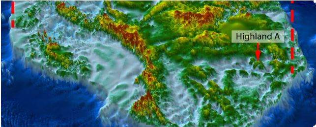
In this new study, Jamieson and colleagues went searching for more granular details of the EAIS' past written in ancient features of the land beneath the Aurora and Schmidt basins, inland of the Denman and Totten glaciers.
"As ice sheets fluctuate, they modify the landscape upon which they rest, leaving a fingerprint," the researchers explain in their published paper. "But it is rare to find unmodified landscapes that record past ice conditions."
The EAIS formed around 34 million years ago when Antarctica iced over and has advanced, retreated, thickened, and thinned, as temperatures fluctuated over geological epochs.
The ice sheet has remained fairly stable for the last 14 million years, covering the vast eastern part of the Antarctic continent, yet the extent of ice sheet retreat during warm intervals remains uncertain.
Scanning the Aurora-Schmidt basins, the team found an ancient landscape 300 kilometers (186 miles) inland from where the present-day ice sheet meets thesea.
It's a small part of a vast continent, but a very revealing one. The area consists of three river-carved 'blocks' separated by deep troughs about 40 kilometers wide.
An intricate network of ridges and valleys covers the blocks, but these features aren't consistent with the slow, modern-day northward ice flow across this part of the continent.
So it's more likely the terrain formed prior to Antarctic glaciation, when rivers crossed the region to a coastline that appeared as the Gondwana supercontinent drifted apart.
Reality Of Islam |
|

Modern comp

With im
A Sahara De
 9:3:43
2018-11-05
9:3:43
2018-11-05
10 benefits of Marriage in Islam
7:5:22
2019-04-08
benefits of reciting surat yunus, hud &
9:45:7
2018-12-24
advantages & disadvantages of divorce
11:35:12
2018-06-10
6:0:51
2018-10-16
bahlool & the throne of haroun rashid
8:20:35
2018-06-21
4:25:57
2023-02-11
9:30:2
2021-11-12
7:59:14
2018-06-21
5:57:34
2023-03-18
2:2:13
2022-10-08
1:38:41
2021-12-08
5:41:46
2023-03-18
| LATEST |
 HOME
HOME